|
Helen
Dawe Collection -- Index
Series
6
Aerial
Photographs (6.1)
Bog,
Marsh Sechelt (6.2)
General, Panoramic
views (6.3)
General, Panoramic
views (6.4)
Identified
buildings (6.5)
First Nations
of Sechelt (6.6)
Individual
people/groups (6.7)
May Days, picnics,
etc. (6.8)
Resource Industries
(6.9)
Schools (6.10)
Ships
(6.11)
Transportation
(6.12)
Whitaker
family (6.13)
Cook,
Dawe, Steele, Whittaker familes (6.14)
Series
2
General
A-Z -- The Crucils
Series
10
Union
Steamship and All Red Line Companies
Series
11
Captain
Sam and Ada Dawe
Series
13
The
Sechelt Inn
Series
20
Souvenir
brochures, postcards
Series
24
Merry
Island lighthouse
|
Series
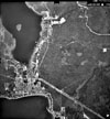
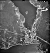
6.1 -- Aerial Photographs, Sechelt and District (Page 6)
The
photographs in this series were taken by the Mines Energy and Resources
Dept. and the RCMP; the majority being taken in 1932. They show the
Village of Sechelt, Selma Park, Wilson Creek, Chapman Creek, Porpoise
Bay and Pender Harbour. The postcards are aerial views of Sechelt
and Porpoise Bay.
1
2 3
4 5
6
 |
6.1.24
1980
-- Aerial survey of Sechelt. Photograph by B.C. Surveys and
Mapping Branch
|
 |
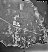
6.1.24a
1947
-- Aerial survey of Sechelt and surrounding area shows Sechelt,
Porpoise Bay and Selma Park wharves. Photograph by B.C. Surveys
and Mapping Branch
|
 |
6.1.24c
1980s
-- Aerial survey of West Sechelt. Photograph by BC Surveys and
Mapping Branch
|
 |
6.1.24d
1980s
-- Aerial survey of Sechelt. Photograph by B.C. Surveys and
Mapping Branch
|
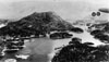 |
6.1.25
1931
-- Aerial view of Pender Harbour. Photograph courtesy Public
Archives Canada. Photograph by Pacific Airways Ltd.
|
Copyright
© The Sechelt Community Archives
|