|
Helen
Dawe Collection
Series
6.5
Bridges, surveyor's posts (1875-?)
Cottages
(1900-1970s)
Sechelt
waterfront, first hotel (1900-1914)
Sechelt
first hotel fire (1900-1914)
Sechelt
second hotel (1910-1930s)
Sechelt
Inn (1906-1973)
Stores,
Post Offices, barn etc. (1896-1973)
Modern
buildings (1973-1982)
Sechelt
Library, Municipal halls (1960s-1970s)
St.
Hilda's Anglican Church (1930s-1970s)
St.
Mary's Hospital (various)
Sechelt
streets (1900s-1980s)
Shorncliffe
Ave, Teredo Street (1935-1983)
Wakefield
Inn, West Sechelt (1981-1982)
Wharf
Road (1906-1979)
|
Series
6.5-- Identified buildings, streets, structures, Sechelt and District
-- Bridges, etc., Page 1
Photographs
are of bridges, cottages, hotels, stores and private houses in Sechelt
and District, many being identified buildings on Sechelt's waterfront.
Excellent photos of Sechelt's first hotel, and the 1914 fire which
destroyed it, Sechelt's second hotel and general store and wharf.
Photographs also of Sechelt Inn, originally Whitaker's house (Vue
de L'Eau or the Beach House), which burned in 1964, St. Hilda's Anglican
Church, and St. Mary's Hospital (in Garden Bay); views of Sechelt's
streets: the Boulevard, Cowrie Street, Inlet Avenue, Shorncliffe Avenue,
and Rockwood Lodge and cottage, Wharf Street and Wakefield Inn in
West Sechelt. Also in this Sub-Series are photographs of Whitaker's
house at Selma Park, the Bank of Montreal at Madeira Park, Deadman's
Island and the CPR station in Vancouver. Photographers include Charles
Bradbury, Edric S. Clayton. Some photographs are copies from Vancouver
City Archives, Provincial Archives and Vancouver Public Library Collection.
1
2
 |
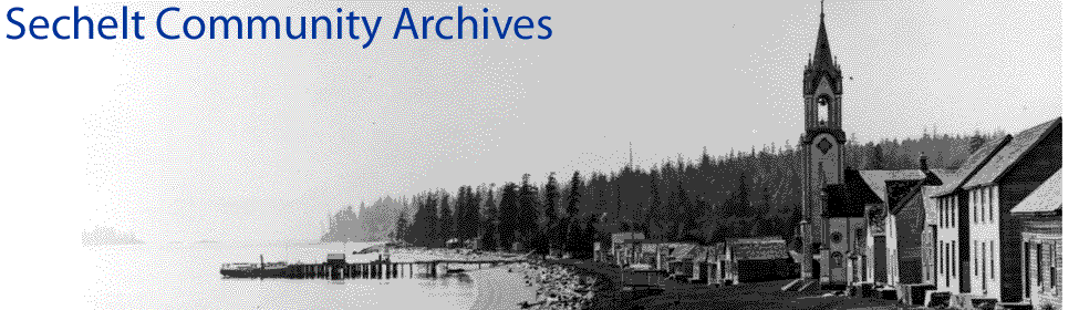
6.5.1
1875
-- Surveyor's Post of D.L. 303 and 304
John
Scales, a Royal Engineer, applied for his 150 acres military grant
on crown land lying between Trail Bay and Porpoise Bay in 1869
and his land grant to District Lot 303 on Trail Bay was recorded
in that year. His purchase of D.L. 304 was recorded in 1975; he
became the first white landowner in the Sechelt area. This picture
shows the survey blaze made by surveyor William S. Jemmett in
1875.
Photograph
by editor Denis Fitzgerald, courtesy The Press newspaper and the
Proctor family
|
 |
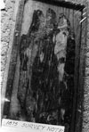
6.5.2
1875
-- Surveyor's Post of D.L. 303 and 304
John
Scales, a Royal Engineer, applied for his 150 acres military grant
on crown land lying between Trail Bay and Porpoise Bay in 1869
and his land grant to District Lot 303 on Trail Bay was recorded
in that year. His purchase of D.L. 304 was recorded in 1975; he
became the first white landowner in the Sechelt area. This picture
shows the survey blaze made by surveyor William S. Jemmett in
1875.
Photograph
by editor Denis Fitzgerald, courtesy The Press newspaper and the
Proctor family
|
 |
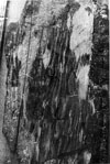
6.5.3
c1911
-- Dry creek, Sechelt Road
This photograph, similar to 6.4.143,
is probably of the wooden bridge over Mission/Wilson Creek before
it was replaced by a culvert in 1951.
Photographer
unknown. Photograph courtesy the Vancouver City Archives.
|
next>
Copyright
© The Sechelt Community Archives
|